Exploring Mars: Q&A on the Stunning New Panoramas from Curiosity and Perseverance
NASA's Curiosity and Perseverance rovers have been tirelessly exploring the Red Planet, and their latest panoramic views offer a breathtaking glimpse into Mars' geological past. These sweeping images, captured from different locations on Mars, reveal strikingly diverse terrains that were shaped by ancient water flows and billions of years of change. Below, we answer key questions about these new panoramas and what they mean for our understanding of Mars.
What Do the New Panoramas from Curiosity and Perseverance Show?
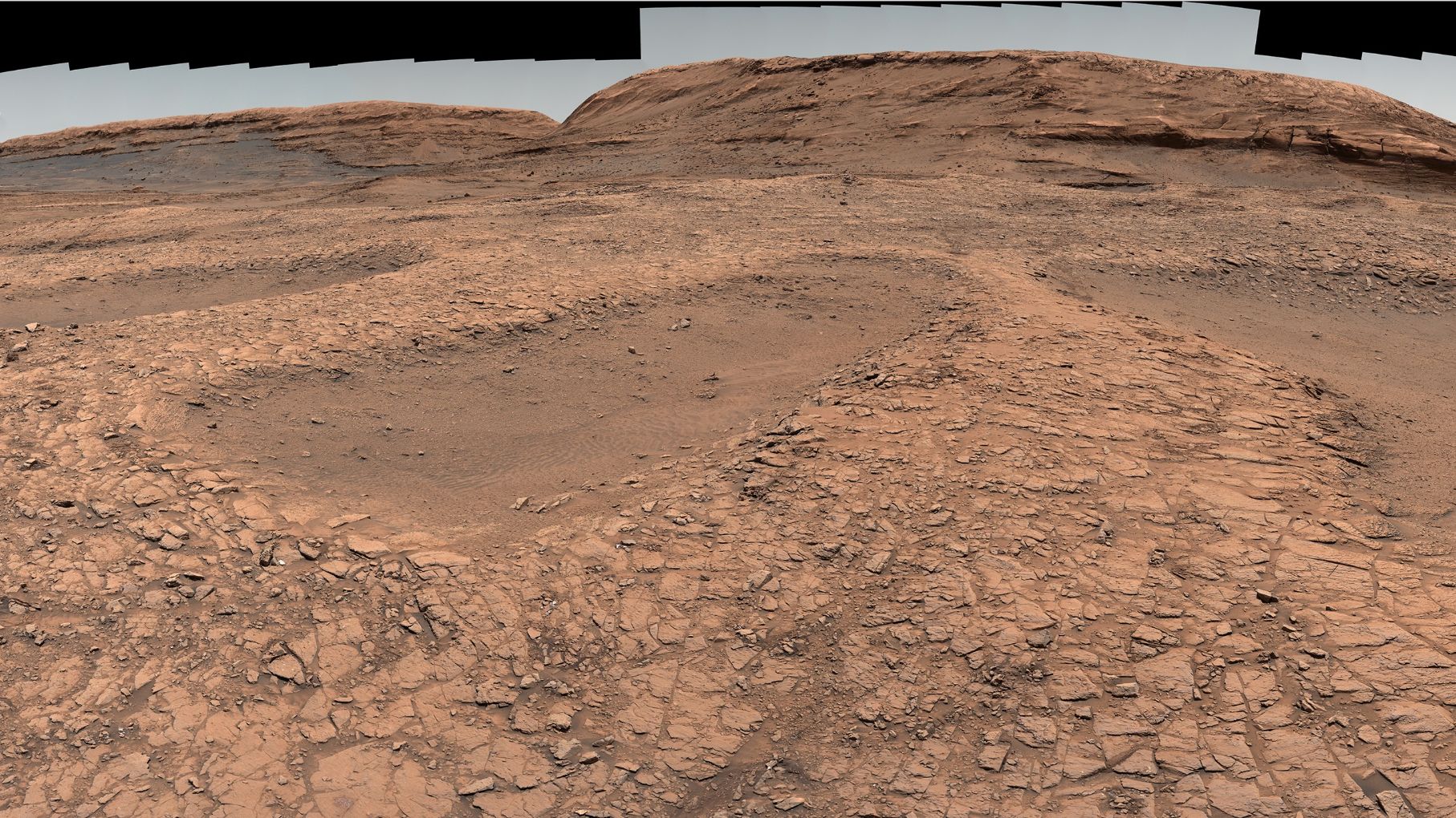
The latest panoramas, beamed back from NASA's twin rovers, showcase two very different Martian landscapes. Curiosity's view from Gale Crater presents a layered, sedimentary terrain with sharp ridges and mesas, evidence of ancient lakes and rivers that once filled the crater. Perseverance, meanwhile, offers a panoramic sweep of Jezero Crater's delta region, where a fan-shaped deposit of sediment tells of a river that flowed into a lake billions of years ago. Both images are stitched together from multiple individual photos, giving scientists a high-resolution, 360-degree view of the rovers' surroundings. These vistas are not just beautiful—they are scientific gold, revealing rock formations and mineral patterns that help piece together Mars' watery past and its evolution into the cold desert we see today.

How Are the Terrains in These Panoramas Different?
The terrains captured by Curiosity and Perseverance contrast dramatically due to their distinct locations and histories. Curiosity, exploring Gale Crater since 2012, provides a view dominated by sedimentary rock layers that rise gradually toward Mount Sharp—a massive mound at the crater's center. These layers were deposited over millions of years by water and wind, creating a staircase of ancient environments. In contrast, Perseverance's panorama from Jezero Crater shows a delta formation—a fan-shaped pile of sediment left by a river emptying into a lake. The delta is rich in clays and carbonates, which are excellent at preserving signs of ancient microbial life. While Curiosity's terrain is more rugged and layered, Perseverance's landscape is smoother but crisscrossed with channels and boulders that tell a story of flowing water and sudden floods. Together, they represent two key chapters in Mars' hydrological history.
What Do These Panoramas Reveal About Ancient Water on Mars?
The panoramas provide compelling visual evidence that liquid water once flowed extensively on Mars. In Gale Crater, Curiosity's images show cross-bedding and ripple marks in the rock—features formed only by moving water. The presence of clay minerals and sulfate salts further indicates that water was present for long periods. Perseverance's view of the Jezero delta includes conglomerate rocks (pebbles cemented together) that are classic signatures of fast-flowing rivers. Additionally, the delta's shape and the distribution of boulders suggest catastrophic flooding events, possibly triggered by ice melt or meteor impacts. Both rovers have also detected organic molecules in their respective regions, hinting that these watery environments could have supported microbial life. The panoramas thus serve as time capsules, freezing Mars' wet era in stone and helping scientists understand how the planet transitioned from a warm, wet world to today's dry, frozen landscape.
How Were These Panoramic Images Captured and Processed?
Creating these immersive panoramas is a painstaking process involving both the rovers' imaging systems and careful work on Earth. Each rover uses a suite of cameras: Curiosity relies on its Mastcam (a multispectral imager) and its Navcam (navigation cameras), while Perseverance uses its advanced Mastcam-Z, which has zoom capabilities and higher resolution. To build a panorama, the rover takes dozens to hundreds of overlapping images by rotating its mast in a predetermined pattern. These raw images are then sent to Earth, where they are stitched together using software that corrects for angle, lighting, and color. Scientists often enhance the colors to bring out subtle differences in rock composition—though they avoid artificial changes. The result is a seamless, 360-degree view that lets viewers feel as if they are standing on Mars. The process can take days to plan and execute, ensuring each photo is clear and well-exposed.
Why Are These Panoramas Important for Science and Exploration?
These new panoramas are not just public engagement tools; they are critical for mission planning and scientific discovery. By providing a wide-angle view of the terrain, they help scientists identify interesting rock formations, sediment layers, and potential sample sites. For Perseverance, the panorama of the delta guides the rover's path as it collects rock cores for future return to Earth—samples that could contain traces of ancient life. Curiosity's panorama helps researchers reconstruct the sequence of environmental changes in Gale Crater, refining models of Mars' climate history. Additionally, these images allow the public to explore Mars in a vivid, interactive way, fostering global interest in space exploration. Each new panorama adds a piece to the puzzle of whether Mars ever harbored life, and if it did, what that life might have looked like.
How Do the Rover's Instruments Enhance What We See in the Panoramas?
The panoramas are far more than pretty pictures—they are integrated with data from the rovers' scientific instruments. Curiosity's ChemCam can fire a laser at rocks seen in the panorama to determine their chemical composition, while its APXS (Alpha Particle X-ray Spectrometer) offers detailed element analysis. Perseverance's SuperCam similarly uses a laser and spectrometer to identify minerals, and its SHERLOC instrument looks for organic compounds. These instruments can target features highlighted in the panoramas, such as veins of sulfate or spots of clay. For example, a light-toned rock in a panorama might be examined by laser to reveal it's rich in silica—a mineral that preserves fossils. Thus, the panoramas act as a visual index of where to deploy these sophisticated tools, making each image a roadmap for scientific investigation.
What Can We Expect from Future Panoramas?
As both rovers continue their missions, even more impressive panoramas are on the horizon. Curiosity is slowly climbing Mount Sharp, and each higher vantage point will offer broader views of the crater and its central mountain, potentially revealing layers deposited at different times. Perseverance will eventually drive onto the top of the Jezero delta, providing a bird's-eye perspective of the fan shape and its relationship to the crater rim. Future panoramas may also include 3D versions or enhanced color palettes to highlight minerals invisible to the naked eye. Moreover, Perseverance's companion, the Ingenuity helicopter, has already captured aerial panoramas that complement the ground views, giving scientists a dual perspective. Each new panorama will refine our geological maps and edge us closer to answering the ultimate question: Did life ever arise on our neighboring planet?